
Peace River Forest Area Update:
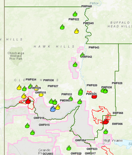
GWF018 is currently classified as Out of Control (OC). It grew to the south by an estimated 19,000 ha yesterday and is now estimated to be 45,154.00 ha in size. It is located on both sides of the Peace River, and is approximately five kilometers east of Cleardale and 13 kilometers southwest of Worsley. Wildland firefighters assisted by air support and heavy equipment are working to contain the wildfire. Hwy 64 is closed from Range Road 74 to Range Road 91. Clear Hills County has issued an evacuation alert for area residents. The Kimiwan Complex Wildfire PCX001 (SWF068 and PWF038) – SWF068 is classified as Out of Control (OC). It is estimated to be approximately 95,836.00 ha in size. Peavine Metis Settlement is under a mandatory evacuation notice due to the fire’s activity on the southwest flank. The wildfire’s north perimeter has crossed Seal Lake Road and South Harmon Valley Road (Twp. 820) is approximately 34 kilometers south of Cadotte Lake and 39 kilometers south of Little Buffalo. PWF038 is also OC, and approximately 6,207 ha. It has remained relatively stable, with wildland firefighters patrolling and putting out hotspots to maintain containment lines.
Continue to stay informed by subscribing to Alberta Wildfire updates by entering your email. To view wildfires on a map, download the AB Wildfire App or visit the Wildfire Status page.
Caution is advised when traveling on area highways due to smoke conditions, especially in low lying areas. For road closures, visit 511 Alberta.